Historic Maps in the Mansfield Library
The Regional and Historic Maps collection held in Archives and Special Collections contains a variety of rare and unique maps related to western expeditions and explorations, railroad surveys, boundary surveys, territories, roads and trails, Montana cities and counties, Native American reservations, national forests and more. Copies of many of these maps are also available in the Mansfield Library's general map collection on Level 1 and may be checked out.
For more information on historic maps related to Montana, GIS data, aerial imagery, or other map types, please navigate to those specific pages of this guide.
Map Resources Documenting Indigenous Peoples
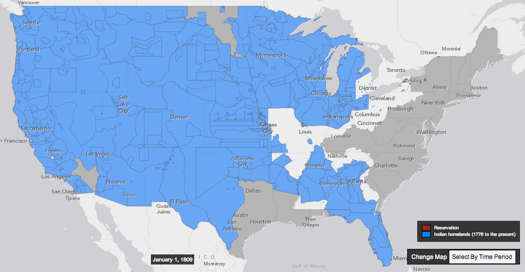
Decline of Indian Homelands Interactive Map
This interactive map, created by University of Georgia historian Claudio Saunt and Slate's Rebecca Onion, shows the decline of Indian homelands from 1776 to 1887. is looking to correct that, at least in the case of Europeans' violent seizing of Native Americans' land. The map was developed to to supplement Saunt's book, West of the Revolution: An Uncommon History of 1776, and shows how rapidly European-Americans over 1.5 billion acres from indigenous peoples residing in the present-day United States. source: Vox
-
Invasion of America Interactive Map"Between 1776 and 1887, the United States seized over 1.5 billion acres from America's indigenous people by treaty and executive order. This interactive map illustrates every Native American land cession during that period through the use of government documents and other primary sources.
-
Tribal Nations Map"The Tribal Nations Map Gallery includes printable PDF wall-map versions of the Indian and Ceded Lands Web Services."
-
Indian Land Cessions in the United States, 1784-1894Maps from the Eighteenth Annual Report of the Bureau of American Ethnology as scanned by the Library of Congress.
-
Yup'ik Environmental Knowledge ProjectOver the last ten years Calista Elders Council (CEC) staff has worked with elders from Bering Sea coastal communities to document Yup'ik place names. This work was initiated and encouraged by CEC's Board of Elders as well as community members.
-
Aboriginal Mapping Network (AMN)The Aboriginal Mapping Network (AMN) was established in 1998 as a joint initiative of the Gitxsan and Ahousaht First Nations and Ecotrust Canada. Over the years the network has grown from its humble beginnings as a knowledge sharing forum for local First Nations technicians, leaders and decision makers to become a valuable strategic resource for practitioners of traditional knowledge mapping around the world.
-
 Maps and Memes
by
Call Number: 971.00497 E115MISBN: 9780773544482Publication Date: 2015-01-01Exploring alternative conceptualizations of maps and mapmaking, Maps and Memes theorizes the potentially creative and therapeutic uses of maps for indigenous healing from the legacies of residential schools and colonial dispossession. Gwilym Eades proposes that maps are vehicles for what he calls "place-memes" - units of cultural knowledge that are transmitted through time and across space.
Maps and Memes
by
Call Number: 971.00497 E115MISBN: 9780773544482Publication Date: 2015-01-01Exploring alternative conceptualizations of maps and mapmaking, Maps and Memes theorizes the potentially creative and therapeutic uses of maps for indigenous healing from the legacies of residential schools and colonial dispossession. Gwilym Eades proposes that maps are vehicles for what he calls "place-memes" - units of cultural knowledge that are transmitted through time and across space. -
 Cartographic Encounters
by
Call Number: 978.02 S55962CISBN: 1861894368Publication Date: 2009-07-15In this vital reinterpretation of American history, Short describes how previous accounts of the mapping of the new world have largely ignored the fundamental role played by local, indigenous guides. The exchange of information that resulted from these cartographic encounters allowed the Native Americans to draw upon their wide knowledge of the land in the hope of gaining a better position among the settlers.
Cartographic Encounters
by
Call Number: 978.02 S55962CISBN: 1861894368Publication Date: 2009-07-15In this vital reinterpretation of American history, Short describes how previous accounts of the mapping of the new world have largely ignored the fundamental role played by local, indigenous guides. The exchange of information that resulted from these cartographic encounters allowed the Native Americans to draw upon their wide knowledge of the land in the hope of gaining a better position among the settlers. -
 Another America
by
Call Number: 970.00497 W275aISBN: 0312150547Publication Date: 1997-03-01Another America is the first book to present rare and seldom-seen maps made by Native Americans. These maps, which lay little known and little studied for the last 300 years, open a window on the North American continent as it was understood and experienced by its original inhabitants. With meticulous research, this book brings to life the people, the places, and events of this Native American history.
Another America
by
Call Number: 970.00497 W275aISBN: 0312150547Publication Date: 1997-03-01Another America is the first book to present rare and seldom-seen maps made by Native Americans. These maps, which lay little known and little studied for the last 300 years, open a window on the North American continent as it was understood and experienced by its original inhabitants. With meticulous research, this book brings to life the people, the places, and events of this Native American history.


USGS Geologic Atlas of the United States
The Geologic Atlas of the United States is a set of 227 folios published by the U.S. Geological Survey between 1894 and 1945. Each folio includes both topographic and geologic maps for each quad represented in that folio, as well as description of the basic and economic geology of the area.
Texas A&M has digitized the entire set these folios and they are available to view on their Digital Collections page. The Mansfield Library has physical copies of the folios 1 through 211 in the Montana Room.
Online Railroad and Transportation Map Resources

-
Montana Railway System MapMap shows the various lines running across the state and the companies that manage them, created 2010.
-
Department of Transportation (DOT) Digital Special CollectionsDOT Online Digital Special Collections Site contains historic reports, circulars, manuals related to transportation.
-
Library of Congress Railroad Maps 1828-1900Included in the collection are progress report surveys for individual lines, official government surveys, promotional maps, maps showing land grants and rights-of-way, and route guides published by commercial firms.
-
Maps of the Union PacificThis site has current and historical maps of Union Pacific Railroad routes available for download as gif or pdf.
-
Northern Pacific Railway MapsThis resource is the guide to the Northern Pacific Railway Maps and Atlases collection held at the Minnesota Historical Society. MNHS holds the bulk of the NP Railway records.
More Online Historic Map Resources
These links provide access to additional historic map resources and thousands of digitized maps at other institutions.

source: Via Eastern map from David Rumsey Historical Map Collection
-
David Rumsey Historical Map CollectionThe David Rumsey Historical Map Collection has over 17,400 maps online. The collection focuses on rare 18th and 19th century North American and South American maps.
-
Library of Congress Map Collections"The Geography and Map Division of the Library of Congress holds more than 4.5 million items, of which Map Collections represents only a small fraction, those that have been converted to digital form."
-
Mapping America: Every City, Every BlockBrowse local data from the Census Bureau's American Community Survey, based on samples from 2005 to 2009.
-
Old Maps OnlineThe OldMapsOnline Portal is an easy-to-use gateway to historical maps in libraries around the world. It allows the user to search for online digital historical maps across numerous different collections via a geographical search.
-
Panoramic MapsA selection of panoramic maps from the Library of Congress of locations across the United States.
-
Perry-Castañeda Library Map CollectionThe University of Texas at Austin has an excellent collection of digitized maps from around the world.
-
W.H. Pugsley Collection of Early Canadian MapsCollection contains 50 digitized maps each with a 72 and 300 dpi jpg for download.
-
University of Alabama Historical Map ArchiveHistorical maps of Montana viewable as a jpeg or zoomable pulgin.
-
University of Illinois Urbana-Champaign Historical Maps OnlineThe intent of the Historical Maps Online project is to electronically publish the images of maps charting the last 400 years of historical development in Illinois and the Northwest Territory.
-
Washington State Library and Archives Historical MapsThe State Archives and the State Library hold extensive map collections dealing with the Washington State and the surrounding region. Maps for this digital collection will be drawn from state and territorial government records, historic books, federal documents and the Northwest collection.
-
World Digital LibraryThe World Digital Library (WDL) makes available on the Internet, free of charge and in multilingual format, significant primary materials from countries and cultures around the world. Site includes historic maps from across the globe.
-
Digital Public Library of AmericaThis site features digitized content from archives, museums, and libraries throughout the U.S., including maps.
-
Digital HistoryWebsite featuring historical maps of states, territories, Native American lands, National Parks, exploration routes and much more.
-
NOAA Historical Maps and ChartsThis site contains historical nautical maps and charts maintained by the Office of Coast Survey.